

I visited Muynak recently with a senior representative of the British parliament. I’d read a lot about the Aral Sea, since the 1980s when I first worked on Soviet issues (as they were then). It’s one of those things – not by any means unique to the former Soviet Union – that illustrates humanity’s ability to affect nature on a large scale, and the kind of negative consequences that can result.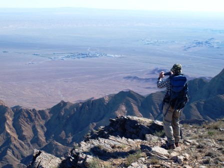
Writing anything that does justice to the set of issues around the Aral Sea’s disappearance and its impacts in terms of the environment, health and economics would need a book, not a short blog entry. But I’ll just note two things that struck me about the landscape. The first is that to my surprise (though perhaps it shouldn’t have been) we approached Muynak through agricultural land and marshland, and area visibly rich in bird life. The second is the sea that isn’t there, and the way that the former sea bed is being planted with saxaul and grasses to stabilise the soil and reduce the dust storms. It’s clear that the priority is adaptation – adjusting to what has happened, encouraging the development of an alternative eco-system, tempering the most damaging effects of the disappearance of the sea.
A week later I was near Zerafshan, to climb what I am told is, at 974 metres, the highest peak in the Kyzyl Kum. It’s another dry landscape, though with a surprising amount of vegetation. We drove for 10 hours from Tashkent and camped at the foot of the ridge, by a dried-up stream bed that issued from a deep crack in the mountains. That was where we went the next morning, first along the bottom of a ravine, then steeply up onto one of the spidery branches of the main ridge, and on past spectacular cliff-top views to the summit.
I like driving and walking. You get a sense of the scale and shape of the country that you don’t get if you fly. It’s also good to stop on the way, though this time we bypassed Jizzakh and Samarkand, and only paused briefly in Navoi. Driving, you get a sense of the flatness and the emptiness of the desert areas – driving on long roads with no bends for miles and miles; and you get a sense of strategic geography, for example the importance of the narrow passes through the hills north-east of Samarkand, or the way that in different ways mineral deposits and the availability of water affect the location of settlements in the Kyzyl Kum. I look forward to exploring further over the summer.